Henry Street Safe Routes to School
Construction for the Henry Street Safe Routes to School Project began in April 2023 and was completed in May 2024.
Project Background:
Following considerable public feedback from community members advocating to incorporate bluestone sidewalks into the project, in June 2021, then Director of Grants Management Kristen Wilson and GPI Project Manager Amanda Joy presented to the Common Council Finance and Audit Committee about the topic. Their presentation outlined the pros and cons of bluestone as a sidewalk material and cost estimates for installing new bluestone, resetting historic bluestone, and installing new concrete along Henry between Wall and Pine Streets. A copy of the presentation pdf can be found under Documents to the right.
The Committee chose to fund the option of resetting historic bluestone and recommended it for passage at the July full Common Council meeting. A recording of the discussion can be found here: CoK Common Council Finance Committee Meeting 6/9/2021.
On July 14, 2021, the Common Council passed Resolution 147 of 2021 to increase the bond ordinance by $115,000 to cover the cost of resetting historic bluestone between Wall and Pine Street. This resolution is also located under Documents to the right.
Project Description:
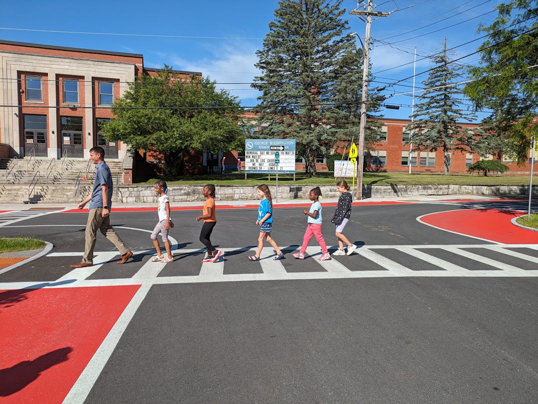
Henry Street is a well-traveled route that runs through the heart of Kingston — it's especially important to young students headed to and from school at George Washington Elementary and for people on their way to many other Midtown destinations.
Regrettably, most travelers find that the poor sidewalk conditions and lack of ADA-compliant ramps, crosswalks, and bicycle infrastructure make Henry quite difficult to traverse and road conditions are equally as hazardous for drivers.
The good news is that change is coming; with funding from the NYSDOT Transportation Alternatives Program, the City is working with engineering consultants GPI to develop designs that will correct these issues for all users and create a safe route to school for young travelers.
The project will provide new pedestrian and bicycle features all along Henry from George Washington up to Broadway. For drivers and cyclists, the existing pavement will be resurfaced to provide a smoother ride. Roadway striping will clearly define 7-foot-wide parking areas on both sides and two 11-foot travel lanes. Minor drainage improvements will be made where the curb line is expected to impact existing drainage structures.
Five-foot-wide concrete sidewalks on both sides of the street to accommodate pedestrians and younger cyclists are proposed. More experienced bicyclists will share the travel lanes with vehicles. A grass maintenance strip will separate the curb from the sidewalk and will include new trees carefully placed to avoid future utility line impacts.
A secure bicycle shelter will be installed at George Washington both for students and general public use.
In December of 2020, the City presented a virtual public information meeting about the proposed improvements and invited community members to offer feedback. Recordings of the meeting in English and Spanish are available for viewing on the CoK YouTube Channel:
Henry Street Safe Routes to School Project Public Meeting & Presentation
Reunión Pública Virtual del Proyecto Rutas Seguras a la Escuela en la calle de Henry
●●●
Design History
Design for the Henry Street Safe Routes to School Project began in 2018 to provide facilities for pedestrians and bicyclists along the roadway, specifically to ensure that students can safely travel to the George Washington Elementary School. The City and the engineering consultants (GPI) met with people from the community during Project Advisory Committee (PAC) Meetings to discuss how to best re-design the street for walkers and people on bikes. At the PAC meetings, ten (10) different street design options were considered. PAC members weighed constraints such as the width of the roadway, need for parking, trees, and the project budget when looking at the design options.
To keep the project costs lower, the curb must stay in approximately the same location so we don't interfere with the existing drainage structures or need to add more pavement. Also, the project must be built within the public right-of-way, aka on the City’s property. Many features, such as retaining walls, stairs, porches, stoops, and buildings on the street are additional constraints. Taking these factors into account and considering the number of residential buildings that rely on street parking, the PAC determined that there isn't enough space on the street to provide dedicated bicycle facilities.
The PAC determined that a shared-use path on one side of the street would be a good compromise. The shared-use path alternative would provide two 11-foot travel lanes, 7-foot parking lanes, a 5-foot sidewalk on the north side of Henry, and an 8-foot shared-use path on the south side. This would leave room on the north side for a 4-to-5-foot green space between the curb and the sidewalk for trees, utility poles, signs, hydrants, snow storage, etc. The shared-use path on the south side would not leave any room for a green space between the curb for the items listed above, so all of the utility poles would have to be moved to the north side. This alternative was presented during the Public Information Meeting on March 5, 2019, and was initially met with positive feedback.
Design Presented on March 5, 2019


However, after further consideration and discussions, many concerns arose about the shared-use path alternative. Specifically by moving the utility poles all to the north side of Henry Street, no shade-height trees could be planted along the roadway. This could have a negative impact on pedestrians and bicyclists, who would no longer be protected from the sun. Additionally, the shared-use path would need to ramp up and down for each driveway. Due to the number of driveways along Henry, this could lead to a pretty up-and-down ride for a bicyclist. Also as mentioned above, there would be no green space between the curb and the shared-use path, so there would be no room for snow storage on the south side. With the retaining walls throughout the corridor, it could become quite difficult to find places for plows to deposit snow during a large storm. For these reasons, another design option is being proposed.
The current design option is to provide 5-foot-wide concrete sidewalks on both sides of the street. This would enable school-age children to ride their bicycles on the sidewalk. Older and more experienced bicyclists would use the travel lane with vehicles. Bicycle-in-lane signs would be added throughout the street to alert vehicles about sharing the roadway with bicyclists. This alternative would provide green space between the curb and sidewalk on both sides of the roadway. Shade-height trees can be installed where there are no utility poles that would require future tree-cutting/trimming. Smaller trees, shrubs, and plantings can be installed in areas where utility poles exist.
Additionally, these green spaces would provide storage for snow, signs, hydrants, etc. The sidewalks would still need to incline and decline for driveways but will be less of a disturbance to pedestrians and younger bicyclists. These changes would be made as smoothly as possible so they are not abrupt and jarring. Overall, due to the ability to provide shade in the corridor, storage for snow, and a safe space for school-aged bicyclists, this is the preferred alternative that will be constructed.
Please post your comments and feedback on the design in the SHARE YOUR THOUGHTS tab. If you have a story that you'd like to share about Henry Street, feel free to type in in below as well. Thank you!